The municipality of Tiwi is made up of mountainous terrain and coastal plains, with elevations ranging from ten (10) meters to as high as 700 meters above sea level (asl). Tiwi is also composed of rocky cliffs, flat lands, valleys, alluvial fans, and swamps. The topography of the municipality is further discussed in the following subsections: elevation, slope, and landforms.
ELEVATION
Elevation refers to the vertical distance of any object on the Earth’s surface and its relative position above or below sea level. Areas with the highest elevations in the municipality constitute portions of Mount Malinao as claimed by upland barangays. The areas along the coastline and barangays along eastern coastal plain portion of the municipality are the lowest.
The uplands of Tiwi are vastly covered by forests that serve as watershed and habitat for different animal and plant species. According to the Presidential Decree 705, also known as Revised Forestry Code of the Philippines, Section 15, “…no land of the public domain eighteen percent (18%) in slope or over shall be classified as alienable and disposable, nor any forest land fifty percent (50%) in slope or over, as grazing land.” This provides legal protection for the forestry in the given area.
SLOPE
Standard slope range is used to show the degree of inclination in a given area (See Table 1.3.1). Tiwi has varying slopes, ranging from flat to steep terrain due to differences in topographic characteristics of the municipality.
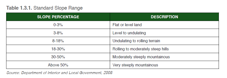
The standard slope range categorizes different slope percentages, from flat or level land (0-3%) to very steeply mountainous slopes (above 50%). Percentages and slope descriptions were prescribed by the National Land Use Committee as standard classification in the country (DILG, 2008).
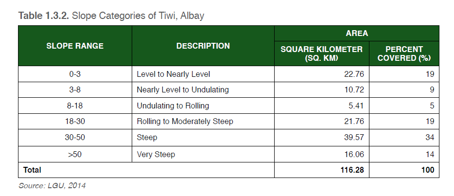
Majority of the municipality’s topography (See Table 1.3.2) is dominated by areas with steep slopes (30-50%), making up an area of 39.57 sq. km or thirty-four percent of the total topography of Tiwi. Rolling to moderately steep slopes (18-30%) and level to nearly level slopes (0-3%) take into account nineteen percent each from the total land area percentage. Very steep slopes (greater than 50%) only take up fourteen percent of Tiwi’s topography, with nearly level to undulating slopes taking up nine percent. Undulating to rolling slopes (8-18%) take up the smallest portion in the municipality’s topography, with an area of 5.41 sq. km or five percent of the topography.
LANDFORMS
Tiwi has two prominent land formations, Mount Malinao and Bolo-Putsan Hill. Mount Malinao is located at the southwest part of the municipality. Bolo-Putsan Hill is found along the boundaries of barangays Bolo and Putsan, at the central-east coastal portion of Tiwi.
Mount Malinao lies within the provinces of Albay and Camarines Sur, and has an absolute location of 13°28’ North latitude and 123°36’ East longitude. It is bounded by the municipalities of Tiwi, Sagnay, Malinao, Polangui, and Tabaco City in Albay, and by the municipality of Buhi in Camarines Sur.
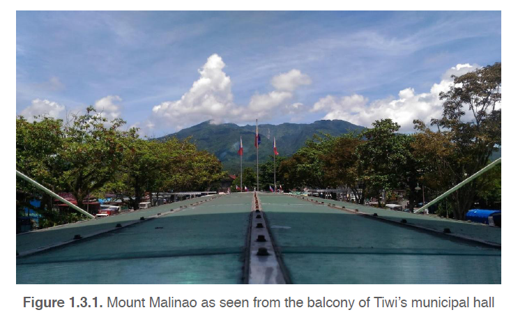
Mount Malinao has an elevation of 1,548 meters and a base diameter of 22.5 kilometers. It is also part of the Bicol Volcanic Arc Complex (See Bicol Volcanic Arc Complex Map). Mount Malinao is a potentially-active andesitic stratocone volcano, and has vents called fumaroles that release steam and gases (Tarbuck & Lutgens, 2014). Due to its proximity, Mount Malinao is easily visible within the municipality of Tiwi (See Fig. 1.3.1), with even portions of the volcano claimed and occupied by barangays with upland areas.
Bolo-Putsan Hill is a geologic feature found along the Putsan-Bolo Range, where limited hornblende-biotite-dacite extrusions are located. Two volcanic plug domes are also found in Bolo-Putsan Hill (Villostas, Florendo, & Guillermina, 1986).
Areas surrounding the hill are rich in clay. A fine-grained soil matter produced from weathered volcanic and pyroclastic materials, clay was accounted to have a total volume of 11,080 cubic meters and a 17,729 geologic tonnage. This total amount of material made Barangay Putsan clay-rich, and prompted the growth of pottery industry in the whole municipality (Villostas, Florendo, & Guillermina, 1986).