The Municipality of Tiwi is a first-class municipality situated at the eastern coast of the Bicol Region, directly facing the Lagonoy Gulf. Tiwi is one of the thirteen municipalities and three (3) cities in the Province of Albay. The municipality lies within 13°27’32.40” North latitude, 123°38’58.80” East longitude (Local Government Unit & Woodfields Consultants, Inc., 2013), and is located at the north- eastern part of the province. Tiwi is bounded by the Municipality of Sagnay, Camarines Sur in the north; the Municipality of Malinao in the south; by the Municipality of Buhi in the west; and the Municipality of Polangui in the southwest. The total land area of the municipality is 116.28 square kilometers. It is 538 km away from the capital, City of Manila, and 39 km away from Legazpi City, the provincial capital of the Province of Albay (Executive Legislative Agreement, 2017).
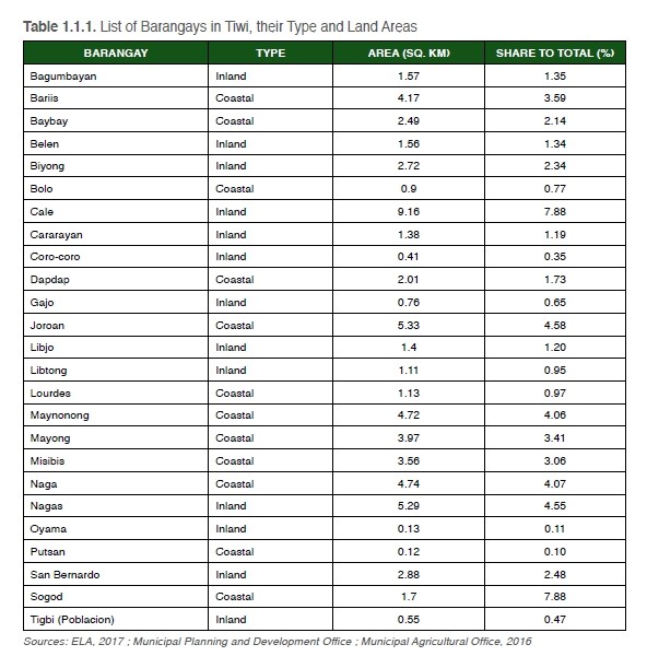
Tiwi is currently divided into 25 barangays, all of which are identified as rural except its poblacion, Tigbi. Table 1.1.1 shows the names of all barangays that constitute the municipality, and whether these barangays are classified as either inland or coastal. Inland barangays are found mainly within the inner portions of Tiwi. Coastal barangays administer their own coasts. In terms of barangay land area, Barangay Cale has the largest, with 9.16 sq. km or 7.88% of the total land area of the municipality. Barangay Putsan has the least land area, with 0.12 sq. km or 0.10% of Tiwi’s total area.
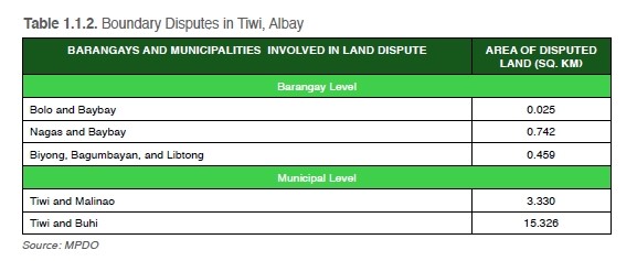
The delineation of these barangay boundaries led to several boundary disputes arising from conflicts between the previous extent of the barangay land areas and the new administrative boundaries. Municipal boundary disputes, too, were present as Tiwi’s administrative boundaries coincide with the municipalities of Malinao, Albay and Buhi, Camarines Sur. These disputes are yet to be settled (See Table 1.1.2).
Property boundaries, disputed areas, and lands with existing claims in Tiwi are shown in the cadastral map of the municipality (See Cadastral Map of Tiwi, Albay). This type of map is defined as a large-scale map that shows property boundaries within a given area (National Council of Education Research and Training, 2006). Property boundaries were delineated per barangay, and disputed areas were labelled according to the barangays that claim these lands. Lands with existing claims are portions of Mount Malinao that are maintained and regulated by barangays within the municipality that are adjacent to the volcano.